The Center for Coastal and Ocean Mapping/Joint Hydrographic Center, located at the University of New Hampshire, is a national center of expertise in ocean mapping and hydrographic sciences.

-

Work Begins on Center of Excellence
UNH has broken ground for the construction of a new 70,500-square-foot building that will be home to the Center of Excellence for Operational Ocean and Great Lakes Mapping, a state-of-the-art facility for research and instruction.
-

Congratulations Jenna!
At the end of the fall semester, Jenna Ehnot successfully defended her master's thesis in ocean engineering with, "Now You See It: Evaluating a Small Object Detection Model for Uncrewed Surface Vehicle Operations."
-
Elias Adediran Featured in Hydro International
CCOM Ph.D. student Elias Adediran has published an article in Hydro International on, "how MBES resolution scales with depth, why AUV/ROV platforms can achieve far higher detail, the limitations of each platform, and why ‘fit-for-purpose mapping’ remains essential in modern ocean mapping."
-
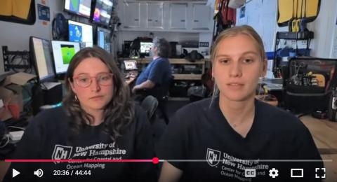
Q&A with Jenna and Natalie
CCOM grad students Jenna Ehnot and Natalie Cook recently took questions and discussed their experiences with marine robotics and their mapping expedition in Lake Erie.


Research

Education

Outreach

UNH Breaks Ground on Ocean Mapping Center of Excellence
UNH News, February 3, 2026
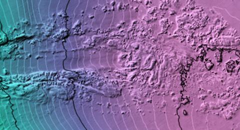
What's at the Bottom of Lake Erie?
Erie Reader, January 27, 2026
Urban Coast Institute Honors Mayer
UNH Today, October 14, 2025
Scientists Use ROV to Explore Bottom of Lake Erie Off Eastern Erie County
Erie Times-News, October 10, 2025
NH's Coastal Economy is Short on Miles, Long on Opportunity
NH Business Review, October 3-16, 2025
Uncovering Naval History in the Solomon Islands
WCVB, October 2, 2025
How Multibeam Echosounder Platform Choice Controls Mapping Resolution
Adediran, E., Hydro International #4 - 2025 BUSINESS GUIDE, 2026.
Mapping Coral Reef Habitats with ICESat-2 and Satellite Imagery: A Novel Spectral Unmixing Approach Compared to Machine Learning
Trudeau, G.A., Lyon, M., Lowell, K., Dijkstra, J.A., Remote Sens. 17(21), 3623, 2025.
Unlocking Hydrographic Data Throughput
Wilson, M., Faulkes, T., Masetti, G., Hydro International, 3(29). 2025.
Automated Islands Generalization Techniques for Nautical Charts
Nada, T., Kastrisios, C., Calder, B., Ence, C., Greene, C., Bethell, A., Geo-Spatial Information Science, 1–14. 2025.
An Introduction to Hydrographic Certification in the United States
LCDR Patrick Debroisse
NOAA
Friday, February 6, 2026, 3:10pm
Chase 105
Analysis of NOAA Classification of Airborne Lidar Data
Dr. Yuri Rzhanov, Research Professor
Dr. Kim Lowell, Research Scientist
UNH Center for Coastal and Ocean Mapping
Friday, January 30, 2026, 3:10pm
Chase 105
Robot Fish, Artificial Shark Perception, and Talking with Lights: A Showcase on MANTA RAY Graduate Research
Hannah Arnholt
Ph.D. Candidate, UNH Ocean Engineering
Friday, January 23, 2026, 3:10 p.m.
Chase 105