As mentioned earlier, one of the greatest challenges facing the Allies was to ensure a steady stream of supplies and troops into France before the capture of a major harbor facility. The plan called for the establishment of two artificial harbors, one off the Omaha Beach and the other off the British sector at Gold Beach (Fig. 5). Ocean tugs towed the harbors, constructed of massive (the largest were 60 m long, 17 m wide, and 18 m high, displacing 6,044 tons) concrete caissons (code-named Phoenixes), across the Channel and sunk them about 3/4 of a mile offshore in about 9 m of water (Fig. 6). Inside the line of caissons, floating loading docks, pier heads and metal roadways, created a sheltered anchorage leading to the beach. For added protection the Allies sunk a string of obsolete warships and merchant ships (known as blockships) along with the caissons.
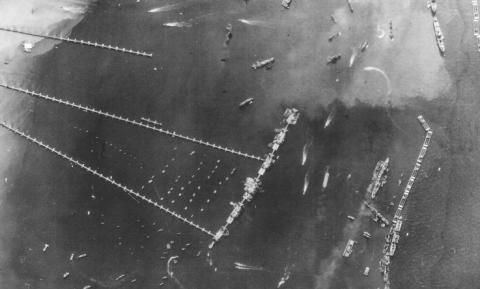
Aerial view of Mulberry Harbor at Gold Beach (Arromanches). Photo from Desquesnes, 1993.
Figure 5
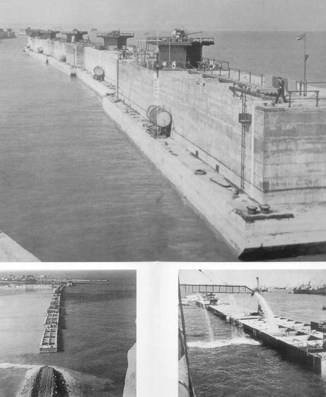
Phoenix caissons before being installed (top), being submerged (bottom right) and in place (bottom left). Photo from Ferrand (1997).
Figure 6
On the 19th - 22nd of June a rare, Force 6 -7 storm struck Normandy, washing more than 800 vessels onto the beaches (Fig. 7). This storm wreaked havoc on the American Mulberry harbor (which was less complete and generally more exposed and vulnerable than the British Mulberry which survived the storm). The storm surge destroyed 20 of the 30 caissons at Omaha Beach forcing the Allies to abandon the American harbor.
Our survey of the remains of the Mulberry harbor focused on an approximately 1.7 km x 200 m wide area parallel to the beach and an approximately 300 x 200 m area perpendicular to the beach (Fig. 8). Surveying was difficult as pieces of some of the caissons come within several meters of the surface, even at high tide. Nonetheless, the multibeam sonar data presents a clear and unparalleled view of the state of destruction of the caissons (ranging from near complete destruction to excellent preservation) as well as the effect of the caissons on local sediment transport. The wreckage of one blockship can be seen lying almost orthogonal to, and on top of, the line of caissons. Most impressive is the ability of the sonar to track the near-vertical walls and remaining steelwork of the better-preserved caissons (Fig. 9).

Omaha Beach after the 19-22 June storm. Note the many vessels washed on the beach. The remnants of the Mulberry Harbor can be seen at the top of the photo - despite the destruction of much of the artificial harbor, its effectiveness as a breakwater can still be seen. Photo from Desquesnes,(1993).
Figure 7

Surveys conducted off Omaha Beach, Normandy. The survey of the Mulberry Harbor off Omaha Beach is seen in two sections parallel to and about 1 km from the beach; the survey of the DD tanks is seen on the eastern edge of the chart approximately 4 km from the beach.
Figure 8
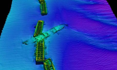
Reson 8125 survey of wreckage of Mulberry harbor off Omaha Beach, gridded at 25 cm resolution and rendered in 3-D. Several caissons can be seen (the two in the middle in very good state of preservation) as well as the wreckage of one of the blockships that had been deployed to add substance to the wave barrier. The distribution of bedforms around the caissons clearly indicates the nature of flow in the region as well as the effect of the wreckage on the flow. Image represents about a 300m x 400m area. Location of these targets can be found on Figure 8.
Figure 9
The images presented here are based on multiple, overlapping passes of the targets allowing insonification from all sides. The data from these multiple passes have been gridded at 25 cm intervals and rendered in 3-D. Given the fact that each grid node represents input from multiple passes, any positional uncertainty will be propagated into the grid resulting in a defocusing of the image. It is thus surprising that the rendered images are so remarkably crisp, particularly in the coherent depiction of vertical structures. The implication is that the horizontal positioning is highly accurate and consistent during the course of multiple passes over the target. When, however, a single swath is examined (i.e., no positional uncertainty), a clear improvement in horizontal resolution can be seen (Fig. 10a and b).

Image of Phoenix caisson constructed from multiple passes over target, gridded at 25 cm and rendered in 3-D.
Figure 10a

Image of Phoenix caisson constructed from a single pass over target, gridded at 25 cm and rendered in 3-D.
Figure 10b