
The Saildrone Surveyor is a 72-foot-long autonomous surface vessel designed for long-endurance ocean mapping missions under sail and/or motor propulsion. CCOM assisted with sea acceptance testing of the Surveyor’s EM304 deep water and EM2040 shallow water multibeam echosounders in early 2021. The Surveyor is equipped with sensors for oceanographic and sound speed profiling, eDNA sampler for biological sampling, and a full suite of EK80 midwater echosounders to further characterize seeps, thermohaline layers, and biological scatterers. After completing a round trip mission from California to Hawaii in early 2022, the Surveyor headed north for its first major survey in the Aleutian Islands during summer 2022.
For additional information about the Saildrone Surveyor, please contact Larry Mayer.
All images courtesy of Saildrone.

Saildrone Surveyor in San Francisco Bay.
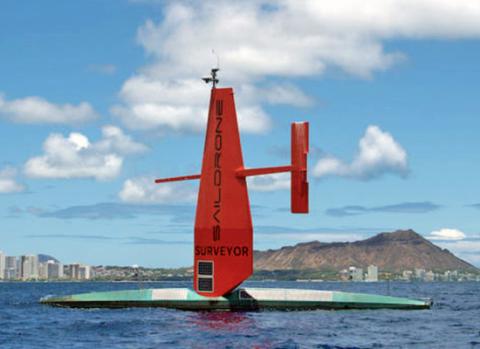
Saildrone Surveyor off the coast of Honolulu.

Saildrone Surveyor in Dutch Harbor, Alaska.

Composite image of Saildrone Surveyor mapping the seafloor with a multibeam echosounder.
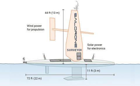
Saildrone Surveyor Specifications
Physical
- Hull Length: 22 m
- Wing Height: 13 m
- Draft: 3 m
Multibeam Sonar
- Kongsberg EM 2040 <400 m
- Kongsberg EM 304 <7,000 m
ADCPs
- Simrad EC150 ADCP, 300-500 m
- Teledyne Pinnacle 45 ACDP
Propulsion
- Primary: Wind (Saildrone wing)
- Auxiliary: 78 hp high-efficiency diesel
- Mapping Speed: 6 knots
- Endurance: 2,500 nautical miles @ 6 knots under power; 9+ months under sail
- Payload Power: 2,000 W steady state; 4,000 W peak
Echo Sounder
- Simrad EK80 for ecosystem monitoring