
Inner Shelf to Jeffreys Ledge
CONTACTS: Larry Ward and Rachel Morrison
DISCLAIMER: All information provided here is for displaying seafloor properties and cannot be used for navigation purposes.
(Access the Interactive Compilation Button)
Use of Maps and Database
The information provided here is freely available for use. However, the University of New Hampshire (UNH) Joint Hydrographic Center/Center for Coastal and Ocean Mapping (JHC/CCOM) should be acknowledged for the surficial geology maps and data.
Recommended Web Citation
Ward, L.G., Morrison, R.C., Bogonko, M., and Johnson, P., 2026, Western Gulf of Maine Surficial Geology and Sediment Database: Inner Shelf to Jeffreys Ledge, University of New Hampshire Center for Coastal and Ocean Mapping, Durham. (((WEBPAGE LINK)))
Use the CCOM Bathymetry Downloader Tool available on the UNH/CCOM-JHC GIS Portal to download data layers.
Full Published Report
Ward, L.G., Morrison, R.C., Bogonko, M., and Johnson, P., 2026, Western Gulf of Maine Surficial Geology and Sediment Database: Inner Shelf to Jeffreys Ledge. University of New Hampshire Center for Coastal and Ocean Mapping and Joint Hydrographic Center (CCOM/JHC) Technical Report, 25 Colovos Road, Durham, NH 03824. DOI: ????????
Map Coordinate System, Projection and Datum
Coordinate System: WGS 1984 UTM Zone 19N
Projection: Transverse Mercator
Vertical Datum: MLLW (bathymetry); NAVD88 (topography)
Overview
The Western Gulf of Maine (WGOM) was shaped by the interactions of marine processes, riverine sediment input, sea-level fluctuations, and multiple glaciations during the Quaternary period which dramatically altered the landscape. Consequently, the seafloor is extremely complex with bathymetric highs, muddy basins, sandy shoals, exposed bedrock, cobble boulder complexes, and extensive marine-modified glacial deposits including drumlins, eskers, and deltas (Figure 1).

Figure 1. Location map of relevant geographic features in the Gulf of Maine, and outline of new surficial geology maps extent (red dashed line). Scale is 1:900,000.
Over the last decade, the University of New Hampshire (UNH) Center for Coastal and Ocean Mapping (CCOM) has conducted numerous studies in the WGOM focused on seafloor characterization, surficial geology mapping, and assessing potential sand and gravel resources. This work has led to the development of high-resolution surficial geology maps of the continental shelf off northern Massachusetts, New Hampshire, and southern Maine. (Figures 2–8). The seafloor geoforms (physiographic features) and substrate sediment were classified and mapped based on a modification of the Coastal and Marine Ecological Classification Standard (CMECS) developed by NOAA Integrated Office of Coastal Mapping (IOCM) (FCDC, 2012). The CMECS geologic substrate classification is used to describe seafloor geology due to its adaptability to different databases and use across multiple disciplines. This approach is especially well-suited for developing surficial geology maps in complex environments such as WGOM.

Figure 2. Surficial geology of the WGOM continental shelf classified using the CMECS substrate class. Scale is 1:270,000.

Figure 3. Surficial geology of the WGOM continental shelf classified using the CMECS substrate subclass. Scale is 1:270,000.

Figure 4. Surficial geology of the WGOM continental shelf classified using the CMECS substrate group. Scale is 1:270,000.
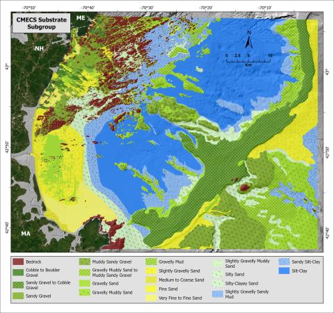
Figure 5. Surficial geology of the WGOM continental shelf classified using the CMECS substrate subgroup. Scale is 1:270,000.

Figure 6. Selected areas showing the CMECS substrate class (least detailed with 3 categories; left) compared to the substrate subgroup (most detailed with 19 categories; right). The top figures are from near the Isles of Shoals, the middle figures are from Portsmouth Harbor, and the bottom figures are from Jeffreys Ledge.

Figure 7. Surficial geology of the WGOM continental shelf based on the CMECS geoforms adapted for paraglacial environments by CCOM. Scale is 1:270,000.

Figure 8. Surficial geology of the WGOM continental shelf based on the CMECS geoform type adapted for paraglacial environments by CCOM. Scale is 1:270,000.
The WGOM surficial geology from Portsmouth Harbor to the Merrimack River was previously mapped by CCOM in 2015 and 2020 (Ward et al., 2016; 2021). The need to update and expand the maps was driven by several factors. First, major changes were made to the CMECS in 2023 to improve upon the original (2012) seafloor substrate or sediment classification scheme (IOCM Ecological Classifications – CMECS; https://iocm.noaa.gov/standards/cmecs-home.html; accessed August 2026). The 2023 updates were completed to facilitate greater detail within the class, subclass, and group categories (Table 1), and had significant input from CCOM. At the same time, CCOM developed a modification of the CMECS geoform classifications adapted for paraglacial environments such as the WGOM (Table 2). Secondly, substantial new high-resolution bathymetry and backscatter surveys became available in the Gulf of Maine (Ward et al., 2026b), which enhanced the ability to identify small-scale features and distinguish between sediment types. Lastly, expansion of the ground truth database through an extensive field campaign carried out in 2022-2023 by CCOM allowed verification of previously unmapped areas.
The surficial maps presented here increase the coverage by ~85% over previous surveys. The new maps extend from approximately Portsmouth Harbor to Cape Ann and seaward to Jeffreys Ledge, covering a total area of ~3,230 km2 (Figure 1). Also available here is the extensive database used for the surficial geology mapping which includes sediment grain size, seafloor photographs, and vibracores.

Table 1. Coastal and Marine Ecological Classification Standard (CMECS) updated classification system from 2023 (see https://github.com/NOAA-OCM/cmecs/tree/main). See Ward et al. (2026a) for complete category descriptions.

Table 2. CMECS geoform categories as modified by CCOM for use in paraglacial environments. See Ward et al. (2026a) for complete definitions of categories.
Interactive Database and Sources
The WGOM surficial geology maps were built from the following resources.
- High-resolution bathymetry and topography compilations: composed of multibeam echosounder bathymetry (MBES) and bathymetric lidar for the offshore, and high-resolution topographic lidar for the onshore region. Both gridded at 4m (Figure 9). See “Gulf of Maine Bathymetry, Backscatter, and Coastal Topography” for details (Ward et al., 2026b) and associated CCOM webpage: XXXXXXXXXXXXXXXXXXX
- Regional bathymetry compilation: lower resolution bathymetry extracted from the GMRT (Global Multi-Resolution Topography grid: GMRT v4.4.0; Ryan et al., 2009) and compiled with the high-resolution compilation to fill gaps in MBES coverage. Gridded at 16m (Figure 10). See “Gulf of Maine Bathymetry, Backscatter, and Coastal Topography” above.
- MBES backscatter surveys and syntheses: based on 112 individual backscatter surveys (Figure 10) and two previously published mosaics. See “Gulf of Maine Bathymetry, Backscatter, and Coastal Topography” above.
- CCOM Western Gulf of Maine sediment and photograph database: composed of 1,033 bottom sediment grain size samples, 1,290 seafloor photographs, and 23 vibracores (Figure 11). See Ward et al. (2026a) for details on original databases and associated interactive database available on CCOM website: XXXXXXXXXXXXXXXXXXXXXXXXXX
- USGS sediment and photograph databases (see Ward et al., 2026a for original sources utilized).

Figure 9. Gulf of Maine high-resolution bathymetry and topography compilation maps (gridding 4m; scale 1:2,200,000). See Ward et al. (2026b) for survey metadata.

Figure 10. Individual MBES backscatter surveys in the GOM shown on top of the regional bathymetry compilation. The surveys were identified during a thorough review of MBES surveys. As is apparent, not all past MBES surveys used for the high-resolution bathymetry compilation had usable backscatter. See Ward et al. (2026b) for footprints and metadata for the backscatter surveys shown here. Map scale is 1:1,600,000.

Figure 11. UNH ground truth database locations, collected between 1971 and 2024 (Ward et al., 2026a). Surface sediment locations are represented by the dark blue dots, seafloor photographs are in light blue, and vibracores are in red. Scale is 1:250,000.
Summary
High-resolution surficial geology mapping in complex paraglacial environments such as the Western Gulf of Maine requires detailed knowledge of seafloor morphology and substrate. To meet this requirement, multibeam echosounder bathymetry (MBES) from the Gulf of Maine and bathymetric lidar datasets from the nearshore were compiled and gridded at 4m; MBES backscatter datasets, where available, were used for identifying textural boundaries between coarse and fine sediments; and extensive ground truth was used to verify the surficial geology classifications. The Coastal and Marine Ecological Classification Standard (CMECS) was applied to identify and map seafloor geoforms (physiographic features) and substrate sediment because of its applicability to interdisciplinary studies and adaptability to a range of supporting data quality. Collectively, the database supported the development of high-resolution surficial maps covering ~3,230 km2 in the WGOM, revealing extensive bedrock outcrops, marine-modified glacial deposits, cobble boulder complexes, offshore, bathymetric highs, deep muddy shelf basins, sand shoals, and fluvial deposits.
The maps and the supporting databases should be viewed using the University of New Hampshire Center for Coastal and Ocean Mapping and Joint Hydrographic Center GIS Portal which allows for interactive viewing of the maps and database.
Reference List
FGDC (Federal Geographic Data Committee, Marine and Coastal Spatial Data Subcommittee), 2012, Coastal and Marine Ecological Classification Standard: FGDC-STD-018-2012, Washington, DC, 343 pp. https://www.fgdc.gov/standards/projects/cmecs-folder/CMECS_Version_06-2012_FINAL.pdf
- For recent updates see CMECS GitHub page: https://github.com/NOAA-OCM/cmecs/tree/main
Folk, R.L., 1954, The distinction between grain size and mineral composition in sedimentary-rock nomenclature: The Journal of Geology, vol. 62, number 4, pp. 344-359. DOI: 10.1086/626171
Folk, R.L., 1980, Petrology of sedimentary rocks: Hemphill Publishing Company, Austin, TX. 182 pp. Accessed May 2019, available online at https://repositories.lib.utexas.edu/handle/2152/22930
Ryan, W. B. F., et al. (2009), Global Multi-Resolution Topography synthesis, Geochem. Geophys. Geosyst., 10, Q03014, https://doi.org/10.1029/2008GC002332.
Ward, L.G., Vallee-Anziani, M., and McAvoy, Z.S., 2016, New Hampshire and vicinity continental shelf: Morphologic features and surficial sediments: BOEM/New Hampshire Cooperative Agreement (Contract M14ACOOO10) Technical Report, BOEM Marine Minerals Branch, Department of Interior, Bureau of Ocean Energy Management, Marine Minerals Division, 45600 Woodland Road, Sterling, VA, 20166, 24 pp.
Ward, L.G., McAvoy, Z.S., Vallee-Anziani, M., and Morrison, R.C., 2021, Surficial Geology of the Continental Shelf off New Hampshire: Morphologic Features and Surficial Sediment: BOEM/New Hampshire Cooperative Agreement (Contract M14ACOOO10) Technical Report. https://dx.doi.org/10.34051/p/2021.31
Ward, L.G., Morrison, R.C., Bogonko, M., and Johnson, P., 2026a, Western Gulf of Maine Surficial Geology and Sediment Database: Inner Shelf to Jeffreys Ledge. University of New Hampshire Center for Coastal and Ocean Mapping and Joint Hydrographic Center (CCOM/JHC) Technical Report, 25 Colovos Road, Durham, NH 03824.
Ward, L.G., Morrison, R.C., Bogonko, M., and Johnson, P., 2026b, Gulf of Maine Bathymetry, Backscatter, and Coastal Topography. University of New Hampshire Center for Coastal and Ocean Mapping, Technical Report, 25 Colovos Road, Durham, NH 03824, 41 pp.
Wentworth, C., 1922, A scale of grade and class terms for clastic sediments: The Journal of Geology, v. 30, no. 5, pp. 377–392. Accessed May 2019, https://www.jstor.org/stable/30063207