
CONTACTS: Larry Ward, Rachel Morrison, Michael Bogonko
DISCLAIMER: All information provided here is for displaying seafloor properties and cannot be used for navigation purposes.
Full Report
Ward, L.G., Morrison, R.C., and Bogonko, M., 2025, Western Gulf of Maine Acoustic Assessment Reference Sites. University of New Hampshire Center for Coastal and Ocean Mapping/Joint Hydrographic Center (CCOM/JHC) Report, 24 Colovos Road, Durham, NH 03824. UNH Scholars Repository (https://dx.doi.org/10.34051/p/2025.14).
Overview
Four Reference Sites were established in 2023 in the Western Gulf of Maine (WGOM) for the specific purpose of testing and evaluating acoustic systems (i.e., sub-bottom seismic profilers) by the University of New Hampshire (UNH) Center for Coastal and Ocean Mapping and Joint Hydrographic Center (CCOM/JHC). Determination of the reference sites was guided by a detailed understanding of the surficial geology and shallow subsurface stratigraphy based on an extensive database developed over several decades by UNH. The four “Reference Sites” represent different physiographic features such as sandy shoals, a paleodelta, and a muddy basin, each with different sediment compositions and sub-bottom structures (Figure 1). Use of the reference sites facilitate qualitative, but geologically informed, comparisons to be made among differing acoustic instruments. The primary criteria for choosing the reference sites were: a mix of sediment types, the presence of strong subsurface reflectors at various depths and scales (for evaluation of sub-bottom seismic systems), a detailed knowledge of the surficial sediment, and, if possible, existing vibracores to help evaluate and interpret seismic images.
The four sites identified that meet these criteria are Portsmouth Harbor Entrance (PHE), Northern Sand Body (NSB), Merrimack Paleodelta (MPD), and Scantum Basin (SB). Two of the sites, NSB and PHE, have been studied extensively by the CCOM/JHC. The MPD has been previously studied by the United States Geological Survey (USGS). Exceptionally strong reflectors were identified in all the reference sites formed by major geological events that have impacted the WGOM including multiple glaciations, sea-level fluctuations, subaerial erosion, and marine processes.
The most common seismic reflectors observed at the reference sites are described in detail in Ward et al. (2025a) and include: bedrock; glaciomarine sediment (including the Presumpscot Formation which is common in the WGOM); paleochannels; erosional unconformities (common in Portsmouth Harbor and the Northern Sand Body reference sites); layered marine shoals (including the Northern Sandy Body feature); paleodeltas (including the Merrimack Paleodelta near the Merrimack River); ravinement surfaces (found in the Merrimack Paleodelta reference site); and sediment gas (common in the Scantum Basin reference site).

Figure 1. Location map of the WGOM reference sites. The shallowest site (PHE) has a maximum depth of ~25 m, while the deepest site (SB) reaches depths of ~125 m. Detailed location and depth information of the reference sites can be found in Ward et al. (2025a).
Data Sources
Each reference site chosen for testing acoustic systems is described below and includes SBP examples and bottom sediment classifications. More details are available in the full report (Ward et al., 2025a). In the following figures, the high-resolution bathymetry shown was published in Ward et al. (2021a), the surficial geology maps are from Ward et al. (2021b) and are colored based on the Coastal and Marine Ecological Classification Standards (CMECS) substrate classifications (FGDC, 2012), and individual sediment samples (shown as pie charts) were collected as part of an extensive field campaign in 2022 (Ward et al., 2024). Examples of sub-bottom seismic profiles (SBP) shown below were obtained in 2023-2024 with CCOM/JHC and several of the Center’s industrial partners (Ward et al., 2025b). For the SBP figures, the ship tracks and direction of the profiles are shown in inset maps, and all vertical scale markings are in 10m increments.
Reference Sites
Portsmouth Harbor Entrance
Portsmouth Harbor Entrance (PHE) reference site is located on a very low-profile sand mound at the mouth and extending seaward of the Piscataqua River (Figures 2 and 3). The thin sand lens overlies the Piscataqua River paleochannel which was eroded into bedrock and infilled with tills and glaciomarine sediment (i.e., Presumpscot Formation) capped by Holocene sands. The bedrock, glaciomarine sediment, and sand lenses provide strong seismic reflectors. Examples of the seismic profiles are given in Figure 4.

Figure 2. Bathymetry of the Portsmouth Harbor Entrance reference site (scale 1:11,000).

Figure 3. Surficial geology of the Portsmouth Harbor Entrance reference site based on CMECS (scale 1:11,000). The circles show the gravel (green), sand (yellow), and mud (blue) percentages of the surficial sediment. Examples of SBPs are shown in Figure 4.

Figure 4. SBPs from the Portsmouth Harbor reference site, showing the underlying bedrock, glaciomarine sediment filling the Piscataqua River paleochannel, and the eroded surface of the Presumpscot Formation sediment. PHE-1 (~2.2 km in length), PHE-4 (1.3 km), and PHE-5 (1.5 km) were collected with an Innomar Medium 100 SBP, and PHE-2 (2.2 km) was collected with a Kongsberg Topas PS40.
Northern Sand Body
The Northern Sand Body (NSB) and the Northern Sand Body - Bedform Field (NSB - BF) reference sites are located approximately 10 to 12 km from Portsmouth Harbor, just landward of the Isles of Shoals (Figures 5 and 6). The NSB is a large, sandy shoal that has been extensively studied by CCOM. There are numerous subsurface seismic reflectors including bedding planes, glaciomarine sediment (Presumpscot Formation), and erosional unconformities (Figure 7). The NSB-BF is located adjacent to the NSB in deeper water and features large-scale bedforms or sand waves that appear to be inactive. Multiple vibracores are available in this area (see Ward et al., 2021c).

Figure 5. Bathymetry of the Northern Sand Body (NSB) and Northern Sand Body – Bedform Field (NSB-BF) reference sites (scale 1:16,000).

Figure 6. Surficial geology of the Northern Sand Body (NSB) and Northern Sand Body – Bedform Field (NSB-BF) reference sites based on CMECS (scale 1:16,000). The circles show the gravel (green), sand (yellow), and mud (blue) percentages of the surficial sediment. Examples of the seismic profiles are given in Figure 7.
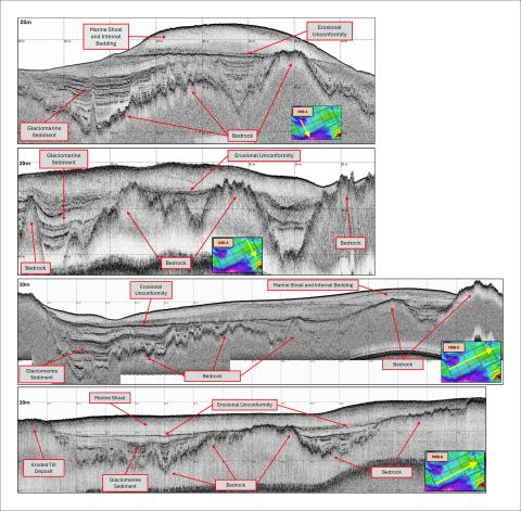
Figure 7. SBPs from the Northern Sand Body reference site, showing the sand shoal internal bedding, underlying bedrock, glaciomarine sediment (Presumpscot Formation), erosional unconformity, and the eroded base of a drumlin. NSB-1 (~1.5 km in length) was collected with an Innomar Medium 100 SBP, NSB-4 (1.5 km) was collected with an EdgeTech 3400, and NSB-5 and NSB-6 (~3.3 km) were collected with a Kongsberg Topas PS40.
Merrimack Paleodelta
The Merrimack River Paleodelta (MPD) reference site is located approximately 29 km south of Portsmouth Harbor and seaward of the mouth of the Merrimack River (Figures 8 and 9). The paleodelta was formed during the last sea level lowstand. The Merrimack River flowed seaward to the lowstand shoreline, depositing sediment and forming a delta, which is now inactive. The paleodelta has strong subsurface seismic reflectors associated with the delta (topset, forest, and bottomset beds), underlying bedrock and glaciomarine sediment, and a ravinement surface related to the Holocene transgression (Figure 10).

Figure 8. Bathymetry of the Merrimack Paleodelta reference site (scale 1:18,000).

Figure 9. Surficial geology of the Merrimack Paleodelta reference site based on CMECS (scale 1:18,000). The circles show the gravel (green), sand (yellow), and mud (blue) percentages of the surficial sediment. Examples of seismic profiles of the paleodelta are shown in Figure 10.

Figure 10. SBPs from the Merrimack Paleodelta reference site, showing the underlying bedrock, glaciomarine sediment (Presumpscot Formation), the paleodelta, and a ravinement surface formed by the Holocene transgression. MPD-1 (top) is ~7 km long and MPD-3 (bottom) is ~5.7 km long. Both were collected with an EdgeTech 3400 SBP.
Scantum Basin
The Scantum Basin (SB) reference site is located ~30 km south of Portsmouth Harbor and 20 km seaward of the mouth of the Merrimack River (Figures 11 and 12). Scantum Basin is the deepest of the reference sites (>90 m) and has the finest sediments, being dominated by muds. The SB reference site has strong subsurface seismic reflectors including underlying bedrock, glaciomarine layered sediment, Holocene muds, and gas in the sediment in the deeper basin (Figures 13 and 14).

Figure 11. Bathymetry of the Scantum Basin reference site (scale 1:24,000).

Figure 12. Surficial geology of the Scantum Basin reference site based on CMECS (scale 1:24,000). The circles show the gravel (green), sand (yellow), and mud (blue) percentages of the surficial sediment. Examples of the seismic profiles are given in Figures 13 and 14.

Figure 13. SBP from the Scantum Basin reference site, showing the underlying bedrock, layered glaciomarine sediment (Presumpscot Formation), and marine muds, as well as gas in the sediment caused by loss of acoustic return. The figures on the bottom show zoomed in areas. SB-2 is ~9.4 km long and was collected with an EdgeTech 3400 SBP.

Figure 14. SBPs from the Scantum Basin reference site, showing the underlying bedrock, layered glaciomarine sediment (Presumpscot Formation), and marine muds. Also, note the loss of acoustic return caused by gas in the sediment in profile SB-4. SB-4 (top) is ~5.6 km long and SB-5 (bottom) is ~4.5 km long. Both were collected with a Knudsen 3260 SBP.
Map Coordinate System, Projection and Datum
Coordinate System: WGS 1984 UTM Zone 19N;
Projection: Transverse Mercator
Horizontal Datum: WGS 1984; Vertical Datum: MLLW
Acknowledgements
The development of the “Western Gulf of Maine Acoustic Assessment Reference Sites” was supported by the University of New Hampshire/National Oceanic and Atmospheric Administration Joint Hydrographic Center Award Number NA20NOS4000196. Field surveys and ground truth sampling were conducted aboard the R/V Gulf Surveyor. The outstanding skill and effort put forth by the RVGS crew (Matthew Rowell, Captain; and Daniel Tauriello, First Mate and Laboratory Manager) are greatly appreciated. We would like to thank each vendor who provided a sub-bottom profiler and skilled operators to assist in the sea trials: ECHO81 LLC (Evan Martzial, Dennis Wilson), EdgeTech (Steven Ferreira, David Olsen, Gary Kozak), Knudsen Engineering Limited (Nolan Pretty, Johnathan Suderman), and Kongsberg Discovery (Therese Mathisen, Tony Dahlheim, Johnny Dybas, Bjørnar Langli, Meme Lobecker).
Reference List
FGDC (Federal Geographic Data Committee, Marine and Coastal Spatial Data Subcommittee), 2012, Coastal and Marine Ecological Classification Standard: FGDC-STD-018-2012, Washington, DC, 343 pp., https://www.fgdc.gov/standards/projects/cmecs-folder/CMECS_Version_06-2012_FINAL.pdf
Ward, L.G., Johnson, P., Bogonko, M., McAvoy, Z.S., and Morrison, R.C., 2021a, Northeast Bathymetry and Backscatter Compilation: Western Gulf of Maine, Southern New England, and Long Island Sound: BOEM/New Hampshire Cooperative Agreement (Contract M14ACOOO10) Technical Report, Department of Interior, Bureau of Ocean Energy Management, Marine Minerals Division, 45600 Woodland Road, Sterling, VA, 20166., 23 pp., https://dx.doi.org/10.34051/p/2021.28
Ward, L.G., McAvoy, Z.S., Vallee-Anziani, M., and Morrison, R.C., 2021b, Surficial Geology of the Continental Shelf off New Hampshire: Morphologic Features and Surficial Sediment: BOEM/New Hampshire Cooperative Agreement (Contract M14ACOOO10) Technical Report, Department of Interior, Bureau of Ocean Energy Management, Marine Minerals Division, 45600 Woodland Road, Sterling, VA, 20166, 184 pp., https://dx.doi.org/10.34051/p/2021.31
Ward, L.G., Morrison, R.C., McAvoy, Z.S., and Vallee-Anziani, M., 2021c, Analysis of Vibracores from the New Hampshire Continental Shelf from 1984 and 1988: BOEM/New Hampshire Cooperative Agreement (Contract M14AC00010) Technical Report, Department of Interior, Bureau of Ocean Energy Management, Marine Minerals Division, 45600 Woodland Road, Sterling, VA, 20166, 173 pp., UNH Scholars Repository: https://dx.doi.org/10.34051/p/2021.26
Ward, L.G., Morrison, R.C., and Bogonko, M., 2024, Southern Maine, New Hampshire, and Northern Massachusetts Continental Shelf Geophysical Database: 2022 Field Campaign – Grain Size Data, Station Summaries, and Seafloor Photographs. University of New Hampshire Center for Coastal and Ocean Mapping/Joint Hydrographic Center (CCOM/JHC), 24 Colovos Road, Durham, NH 03824. UNH Scholars Repository: https://dx.doi.org/10.34051/d/2024.1
Ward, L.G., Morrison, R.C., and Bogonko, M., 2025a, Western Gulf of Maine Acoustic Assessment Reference Sites. University of New Hampshire Center for Coastal and Ocean Mapping/Joint Hydrographic Center (CCOM/JHC) Report, 24 Colovos Road, Durham, NH 03824., UNH Scholars Repository: https://dx.doi.org/10.34051/p/2025.14
Ward, L.G., J.E. Hughes Clarke, and R.C. Morrison, 2025b, UNH CCOM Western Gulf of Maine Acoustic Assessment Reference Sites: Sub-Bottom Profiler Systems Sea Trials. University of New Hampshire Center for Coastal and Ocean Mapping/Joint Hydrographic Center (CCOM/JHC), 24 Colovos Road, Durham, NH 03824., UNH Scholars Repository: https://dx.doi.org/10.34051/p/2025.15