You are here
Articles

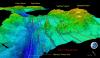
Scientists Map Earth's Deepest Point, Challenger Deep - Before Four Rival Manned Missions Race to the Bottom
Daily Mail
Dec. 7, 2011
Dr. Jim Gardner is quoted in another article about the mapping of the Mariana Trench.
AGU Blogosphere
Dec. 7, 2011
Marine geologist Jim Gardner’s job allows him to command large ships, map underwater bridges, and travel the world’s oceans. And he does it all in the name of the Law — The United Nations Commission on the Law of the Sea, that is.

The Telegraph UK
Dec. 7, 2011
Dr. Jim Gardner discusses how scientists have been able to map the Mariana Trench, the deepest known section of ocean in the world, in greater detail than ever before.

Nature
Dec. 5, 2011
As the ice melts, fresh obstacles confront Arctic researchers. Director Larry Mayer is quoted in this article about the potential problems and possibilities of an ice-free arctic.
New Report Offers Broad Approach to Assessing Impacts of Ecological Damage From Deepwater Horizon Oil Spill
National-Academies.org
Nov. 10, 2011
This interim report from the Committee on the Effects of the Deepwater Horizon Mississippi Canyon-252 Oil Spill on Ecosystem Services in the Gulf of Mexico provides options for expanding the current effort to include the analysis of ecosystem services to help address the unprecedented scale of this spill in U.S. waters and the challenges it presents to those charged with undertaking the damage assessment. CCOM director Larry Mayer is the chair of this committee.
Seacoast Online
Oct. 15, 2011
CCOM participated in Saturday's Know the Coast Day, hosted by the University of New Hampshire Marine Program and New Hampshire Sea Grant. Many CCOM folks turned out to give talks, give demonstrations and interact with the community as they visited out facilities in the Jere A. Chase Ocean Engineering Lab on the Durham campus.
Nature
Oct. 13, 2011
As the ice melts, fresh obstacles confront Arctic researchers. Director Larry Mayer is quoted in this article about the potential problems and possibilities of an ice-free arctic.
UNH Media Relations
Sep. 26, 2011
The second annual Know the Coast Day, hosted by the University of New Hampshire Marine Program and New Hampshire Sea Grant, will be held on Saturday, Oct. 15, 2011. At this free event, UNH’s three marine laboratories – Jackson Estuarine Laboratory and the Jere Chase Ocean Engineering Laboratory in Durham and the Coastal Marine Research Facility in New Castle – will offer visitors of all ages an opportunity to talk to scientists, tour laboratories and research vessels, and get their hands wet learning about the Seacoast’s marine scene.
Hydro International
Sep. 16, 2011
Multibeam sonar, an echo sounding technology commonly used to map the seafloor, can also be used to map and detect gaseous seeps in the water column, according to scientists testing the technology onboard NOAA Ship Okeanos Explorer last week in the Gulf of Mexico. Unlike other types of sonar, multibeam technology is able to survey a wide area of the seafloor and water column.
NOAA News
Sep. 15, 2011
Tom Weber and Glen Rice are featured in this article about Okeanos Explorer's mission to test multibeam sonar’s ability to map gaseous seeps, rather than oil, as oil is more difficult to acoustically detect with the multibeam sonar. Techniques developed during this cruise are intended to help scientists better understand detection of gas seeps which may in turn better inform scientists who are working on techniques to map oil in the water column.
Campus Journal
Sep. 7, 2011
Scientists from UNH’s Center for Coastal and Ocean Mapping/Joint Hydrographic Center are halfway through their six-week mission in the Arctic Ocean aboard the U.S. Coast Guard Cutter Healy.
Toronto Star
Aug. 24, 2011
Two powerful icebreakers — one Canadian, the other American — have just met up in the Beaufort Sea, setting up the latest play in a circumpolar hockey game. More>>
Military.com
Aug. 18, 2011
On Aug. 15, two videographers from National Geographic, a photographer, and a journalist from the University of New Hampshire Alumni Magazine conducted an interview with Center director Dr. Larry Mayer. Dr. Mayer is the chief scientist during the Coast Guard Cutter Healy’s Arctic West Summer 2011 Mission and extended continental shelf mapping with the Canadian coast guard icebreaker Louis S. St-Laurent.
La Tribune
Jul. 11, 2011
This summer, Val Schmidt is participating with some Canadian colleagues in an effort to map the underside of an iceberg using an AUV. They spent last week conducting pre-deployment tests in a lake in Quebec.
UNH Campus Journal
Jun. 22, 2011
James Gardner, research professor at the Center for Coastal and Ocean Mapping/Joint Hydrographic Center, has received the Shepard Medal for excellence in marine geology from SEPM, the Society for Sedimentary Geology. He will be presented with this prestigious medal at the SEPM’s annual meeting in April 2012.
Popular Mechanics
Jun. 14, 2011
With a warming world steadily eliminating sea ice from the Arctic, Northern nations are busy bolstering their claims to the sea floor, trying to pave the way for future economic interests. More than one country has already claimed the North Pole. But staking your claim at the top of the world is a messy and complicated science.
Hydro International
May. 16, 2011
With more than 50 expeditions to sea, amongst them many to the Arctic, and a new role as leader of an inquiry team installed by the National Research Council that will study the effects of the Deepwater Horizon oil spill on the ecosystem services in the Gulf, Larry Mayer is able to connect the two regions that are playing such a big role in today’s and tomorrow’s energy supply of the United States and beyond.
UNH Campus Journal
May. 11, 2011
Kurt Schwehr, a Research Assistant Professor at CCOM, is one of the developers of a web-based oil spill response tool that has been honored as a finalist for the prestigious Samuel J. Heyman Service to America Medal.
Seacoast Online
Feb. 5, 2011
Larry Mayer, professor of Earth science and ocean engineering, director of UNH's Center for Coastal and Ocean Mapping, and co-director of the UNH-NOAA Joint Hydrographic Center, will lead a National Research Council's committee to study the effects of the Deepwater Horizon oil spill on ecosystem services in the Gulf of Mexico in a 30-month inquiry that will produce a final report for elected officials, public policy leaders and the public in fall of 2012.
Science Now
Nov. 16, 2010
When the Deepwater Horizon oil spill erupted into the Gulf of Mexico last April, the only view researchers and citizens had of the gushing oil was the video feed controlled by BP. A team of scientists says it has now found a better way to track oil spills: sonar.
The researchers, from the University of New Hampshire's (UNH's) Center for Coastal and Ocean Mapping (CCOM) in Durham and the National Oceanic and Atmospheric Administration (NOAA), wanted to try sonar because its wide view can look at entire swaths of ocean at the same time. But no one had shown how to use the technology to map or track oil spills. "We were really doing crisis science. ... There were no proven methods for doing this," says team member Thomas Weber, an acoustician at CCOM.
Hydro International
Oct. 7, 2010
"It will be a very interesting question as to whether this data will be made public like all the other bathymetry we have collected," commented Larry Mayer to Hydro International. Mayer served as chief scientist on the Healy during the previous two expeditions and is director of the Center for Coastal and Ocean Mapping in Durham, N.H. "I am not sure how data from the disputed area will be treated," he acknowledged. "We will get the data at the end of the cruise and can process it relatively quickly." Currently all of the bathymetry data that the Healy has collected using its multi-beam echo sounder is available online, whereas the data from the seismic surveys collected on board Canada's Louis S. St-Laurent are not yet public. "I should say that processing is one thing. Analysis is another. The analysis with respect to potential submissions is a longer process," Mayer added.
Using Multibeam Echosounder Backscatter To Characterize Seafloor Features Geocoder Processing Gives Multibeam Echosounder Backscatter an Advantage Over Side Scan Sonar in Producing Reliable Seafloor Maps
Sea Technology
Oct. 7, 2010
Recent developments in multibeam echosounder backscatter processing, specifically an integrated suite of processing algorithms called Geocoder (developed by Luciano Fonseca and Brian Calder of the University of New Hampshire), are now included in most commercially available processing software. These tools allow end users to produce properly corrected backscatter mosaics and add more robust qualitative and quantitative discrimination of seabed materials to their seafloor characterizations.
4D Visualization and Analysis Of Seafloor Vents and Plumes FMMidwater Processing, Generic Water Column Format Allow Rapid Exploitation of Water Column Targets
Sea Technology
Oct. 7, 2010
Dr. James V. Gardner of CCOM and Mashkoor Malik of NOAA participated on the cruise and provided details of the discovery in the journal Eos, Transactions, American Geophysical Union. The discovery of this plume is just one example of the emerging use of these types of multibeam water column data.
UNH Media Relations
Aug. 5, 2010
UNH Tech Campers use the Chase deep tank to test the Sea Perch ROVs they built by running them through an obstacle course set up by divers from the Portsmouth Naval Shipyard.
Reuters
Aug. 5, 2010
With most of a once-massive Gulf of Mexico oil slick no longer a threat, environmental experts say the Gulf coast may have dodged the worst nightmare of a massive catastrophe.


