You are here
Articles
Seacoastonline.com
Oct. 20, 2012
About 500 K-12 students flocked to UNH's Jere Chase Ocean Engineering Laboratory between 10 a.m. and 3 p.m. Friday to participate in educational activities designed to spark their interest in the ocean and in-demand science, technology, engineering and math (STEM) subjects.

UNH Media Relations
Sep. 26, 2012
The third annual Know the Coast Day will be held on Saturday, October 20.

UNH Today
Sep. 20, 2012
Andy Armstrong's Arctic journal is featured in UNH Today. (Photo courtesy of the USGS.)
NOAA Office of Coast Survey
Sep. 7, 2012
NOAA Corps Lt. Briana Welton, a CCOM grad student, and is aboard the R/V Atlantis this summer as part of a U.S.-Canada mapping cruise in the northern Atlantic Ocean. Briana provided the images and text for this post on the Office of Coast Survey blog.
Concord Monitor
Sep. 5, 2012
CCOM Research Assistant Professor Jonathan Beaudoin answers five questions about his work and the discovery of the S.S. Terra Nova.
Foster's Daily Democrat
Sep. 2, 2012
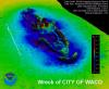
Jonathan Beaudoin, a CCOM Research Assistant Professor contracted to test sonar systems on a research ship, helped discover the wreck of the ship that took Robert Falcon Scott to the Antarctic

UNH Campus Journal
Aug. 29, 2012
Jonathan Beaudoin, CCOM research assistant professor, was aboard Schmidt Ocean Institute’s flagship, R/V Falkor, off the coast of Greenland last month when the sonar systems he was evaluating and calibrating turned up a mast of the S.S. Terra Nova.

USGS Science Features
Aug. 24, 2012
An overview of the five-week expedition aboard U.S. Coast Guard Cutter Healy that is currently underway in the Arctic.

National Geographic
Aug. 21, 2012
A team led by the Schmidt Ocean Institute and including CCOM Researcher Jonathan Beaudoin discovered the wreck of the S.S. Terra Nova on July 11 while testing the new ship R/V Falkor's echo sounders-devices that help map the seafloor using acoustic waves.

The Telegraph
Aug. 15, 2012
The S.S. TERRA NOVA, the ship that took Captain Robert Falcon Scott on his ill-fated mission to the Antarctic 100 years ago, has been discovered off the coast of Greenland.

NOAA News
Aug. 14, 2012
CCOM alum Gerd Glang, recently made rear admiral, will be responsible for the mapping and charting of all United States coastal waters.
NOAA Coast Survey's Blog
Jul. 25, 2012
CCOM alum Nick Forfinkski is leading NOAA Coast Survey’s Navigation Response Team 4 as they conduct a year-long survey of the sea floor in the Port of Houston and Galveston Bay navigational areas.
Geographical
Jul. 20, 2012
CCOM's perspective-view image of the Mariana Trench is featured in the June 2012 issue of Geographical, a publication of the UK's Royal Geographical Society.

National Ocean Service
Jun. 21, 2012
CCOM alum Rachel Soraruf Medley was interviewed for this National Ocean Service podcast about nautical charts.

Boston Globe
Jun. 7, 2012
The NOAA Ship Ferdinand R. Hassler, a federal research vessel that will help update nautical charts on the East Coast, will be commissioned Friday, doubling the size of the Atlantic mapping fleet. The Hassler will be home ported in New Castle, NH, next spring. (Image courtesy of NOAA.)

The Portland Press Herald
Jun. 7, 2012
A federal research vessel that will help update nautical charts on the East Coast will be commissioned Friday, doubling the size of the Atlantic mapping fleet.

Norwegian Petroleum Directorate
May. 22, 2012
This summer, the research hovercraft SABVABAA will embark upon a research voyage from Svalbard to the North Pole. This will be the first and the northernmost polar expedition undertaken with such a vessel.

Sea Technology
May. 1, 2012
In this featured article, postdoctoral research associate Tom Butkiewicz discusses new interactive visualization tools that make ocean flow models more accessible.
UNH Campus Journal
Apr. 18, 2012
Researchers at the Center for Coastal and Ocean Mapping (CCOM) helped develop a new iPad and iPhone application that aims to protect critically endangered North Atlantic right whales from collisions with ships.
The Watchers
Apr. 17, 2012
Scientists have a new map of the deepest trench in the world’s deepest ocean. Researchers at the Center for Coastal and Ocean Mapping/Joint Hydrographic Center at the University of New Hampshire (UNH) have pierced the lightless depths of the western Pacific Ocean and drawn a new picture of the Mariana Trench using sound waves.

Our Amazing Planet
Apr. 16, 2012
Sound waves have allowed scientists to peer through the dark ocean depths and create a new map of the deepest spot in the oceans: the Challenger Deep in the Mariana Trench.

NASA Earth Observatory
Apr. 14, 2012
These NASA Earth Observatory Images were made from data collected and analyzed by researchers at the Center for Coastal and Ocean Mapping/Joint Hydrographic Center at the University of New Hampshire (UNH).
Foster's Daily Democrat
Apr. 14, 2012
Researchers at the University of New Hampshire's Center for Coastal and Ocean Mapping (CCOM) helped develop a new iPad and iPhone application that aims to protect critically endangered North Atlantic right whales from collisions with ships.
SUMOskinny Magazine
Apr. 13, 2012
UNH is straight dominating the whale-saving game right now.

Coordinates
Apr. 12, 2012
For the first time, mariners operating along the U.S. east coast can receive a visual display of all relevant right whale management initiatives and warnings via their iPad or iPhone.


