Research Areas
Research Projects
PROJECT CONTACT
Mariana Images
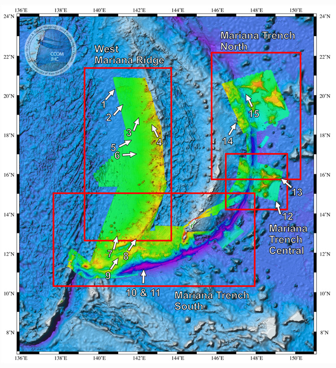
- West Mariana Ridge - Fault Scarp
- West Mariana Ridge - Rough Seafloor
- West Mariana Ridge - Seamounts
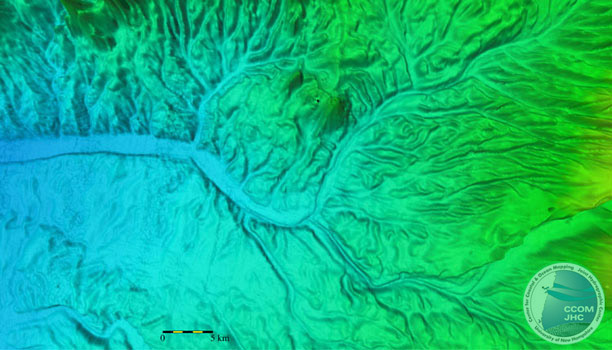
- West Mariana Ridge - Drainage Channel
- West Mariana Ridge - Complex Channel Systems
- West Mariana Ridge - Incised Channel
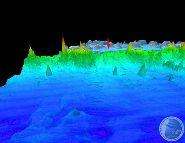
- West Mariana Ridge - Volcanoes
- West Mariana Ridge - West
- West Mariana Ridge - Southern End
- Deepest Depth in the Trench
- Mariana Trench & Trough - Southern Area
- Mariana Trench - Guyots Carried into the Trench
- Mariana Trench - Lagoon Type Feature
- Mariana Trench - Bathymetry Looking NE
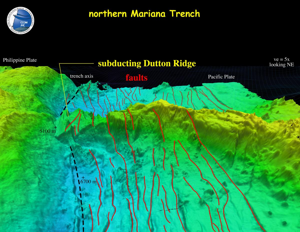
- Mariana Trench - Dutton Ridge
1. West Mariana Ridge - Fault Scarp
Perspective view of the bathymetry of a possible fault scarp with 350 m of relief. The possible fault trends N70E towards the West Mariana Ridge. Vertical exaggeration = 10x, looking N75E.

2. West Mariana Ridge - Rough Seafloor
Perspective view of the bathymetry of the rough seafloor (foreground) down slope from a suspected large ridge collapse (red arrow). The relief of the rough seafloor varies between 50 and 100 m. Vertical exaggeration = 10x, looking E.
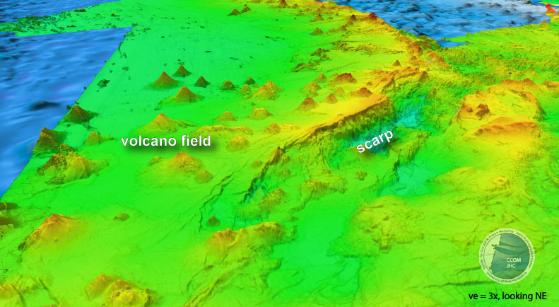
3. West Mariana Ridge - Seamounts
Perspective view of the bathymetry of the linear seamount trends of the West Mariana Ridge that strike N40E to N48E from the main ridge trend. Seamounts of the West Mariana Ridge are typically conical in shape with only a few cratered summits or guyots and they rise to less than 50 m of sea level. Vertical exaggeration = 10x, looking NE. Background behind image is ETOPO2.

4. West Mariana Ridge - Drainage Channel
Close-up map view of upper reaches of a "drainage" channel. The channel floor is ~ 2 km wide.
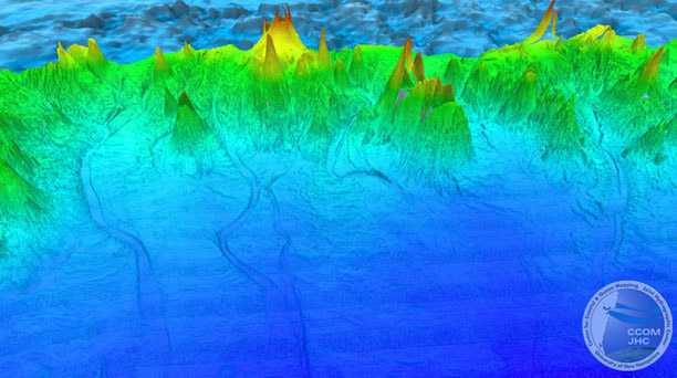
5. West Mariana Ridge - Complex Channel Systems
Perspective view of the bathymetry of the central region of the western flank of the West Mariana Ridge showing an extensive "drainage" system of channels. The channels are as much as 3 km wide, 150 km long and incised 100 m deep. Vertical exaggeration = 10x, looking E.
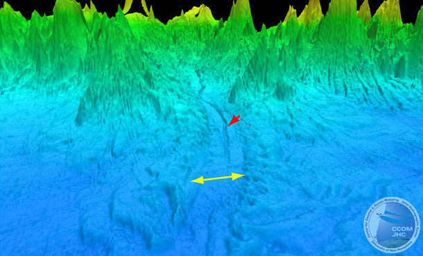
6. West Mariana Ridge - Incised Channel
Close-up perspective view of one of the "drainage" channels showing a broad channel floor (yellow arrow) that has been incised by a younger channel (red arrow). Vertical exaggeration = 10x, looking E.
7. West Mariana Ridge - Volcanoes
Perspective view of the bathymetry looking north of a cluster of large volcanoes located in the southern portion of the mapped area. The volcanoes have base diameters of 20 to 30 km and rise about 2500 m above the basin. Compared to the volcanoes in the central and northern parts of the mapped area, these in the foreground are relatively uneroded, suggesting they may be younger.
8. West Mariana Ridge - West
Perspective view of bathymetry looking north along the West Mariana Ridge. Vertical exaggeration is 5x. The ridge is about 16 km wide and stands 2.5 km above the basin to the east and 3.5 km above the basin to the west. The west flanks of the West Mariana Ridge are about 13° whereas the east flanks are 20° to 30°.

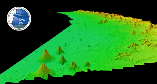
9. West Mariana Ridge - Southern End
Perspective view of the bathymetry of the southern end of the West Mariana Ridge. The abrupt scarp is 3200 m high. A field of 37 submarine volcanoes occurs on the western flanks and adjacent basin. The volcanoes range in height from 1000 m to greater than 2100 m high. Vertical exaggeration 3x, looking northeast.
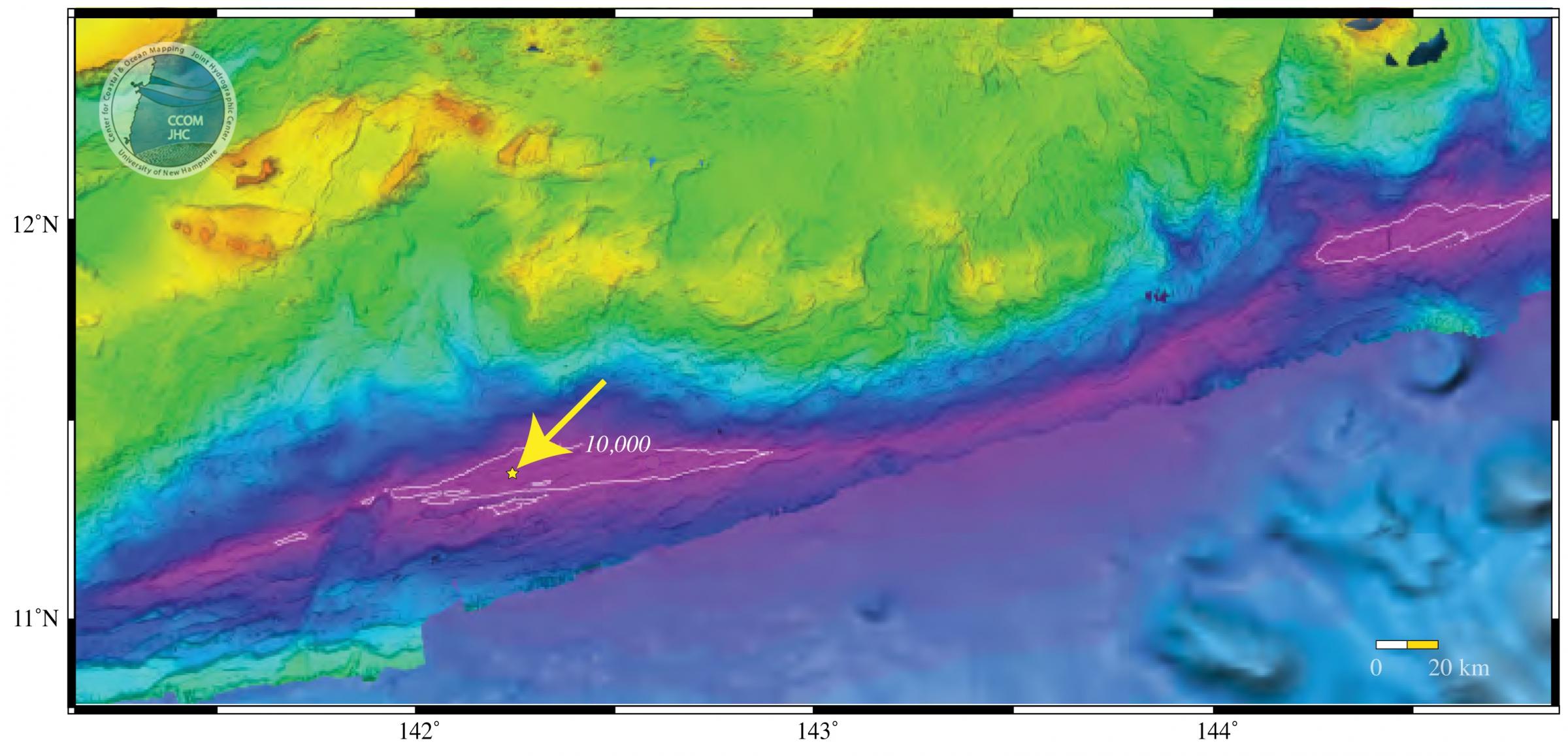
10. Deepest Depth in the Trench
Map view of the bathymetry of southern Mariana Trench area. Arrow points to circle that identifies the location of the deepest sounding in the trench (10,994 m). White contours are 10,000 m isobath.
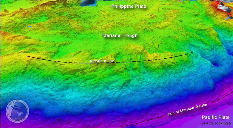
11. Mariana Trench & Trough - Southern Area
Perspective view of the bathymetry of the southern Mariana Trench and Trough area. The forearc bulge area is a region of uplift and intrusion caused by the Pacific Plate underthrusting the Philippine Plate. The Mariana Trough spans the area between the West Mariana Ridge on the west to the Mariana Arc on the east. Vertical exaggeration 3x, looking north.
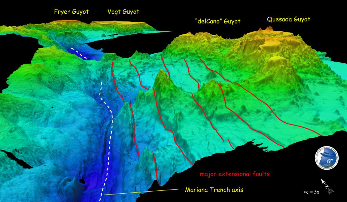
12. Mariana Trench - Guyots Carried into the Trench
Perspective view of the bathymetry looking NNE along the Mariana Trench (white dashed lines). The view shows several guyots (flat-topped seamounts) that are being carried into the trench on the Pacific Plate. The red lines mark major extensional faults that disrupt both the Pacific Plate and the seamounts. Vertical exaggeration 5x.
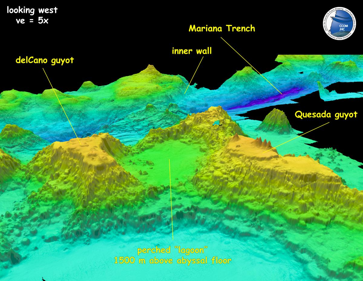
13. Mariana Trench - Lagoon Type Feature
Mariana Trench - Perspective view of the bathymetry looking west across the Mariana Trench from the Pacific Plate to the Philippine Plate. An unusual "lagoon"-type feature (36 x 44 km in diameter) is found surrounded by guyots and perched 1500 m above the abyssal seafloor. Vertical exaggeration 5x.
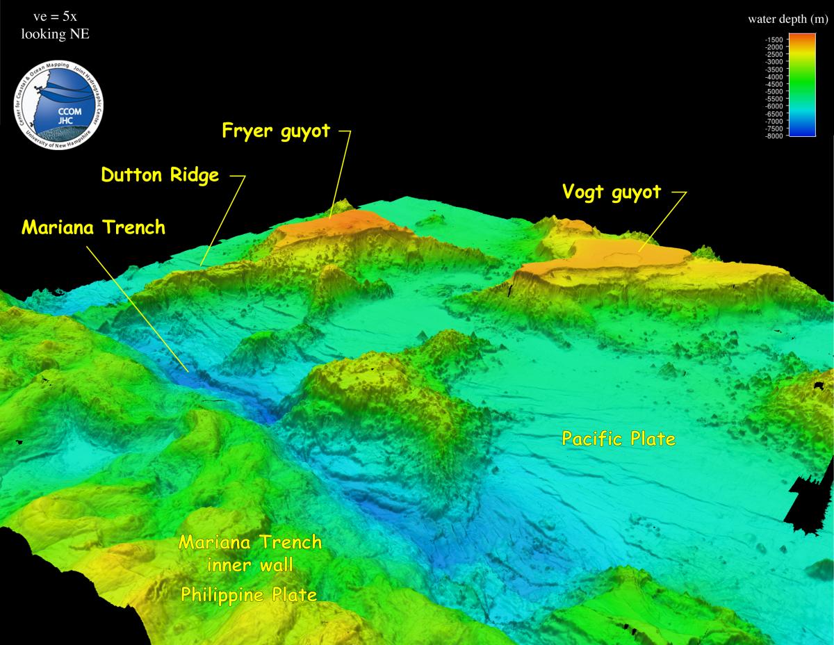
14. Mariana Trench - Bathymetry Looking NE
Perspective view of the bathymetry looking NE from the Philippine Plate at the guyots and ridge approaching the Mariana Trench. Vertical exaggeration 5x.
15. Mariana Trench - Dutton Ridge
Perspective view of the bathymetry of Dutton Ridge as it is being subducted into the Mariana Trench. Numerous extensional faults (red lines) disrupts the seafloor and the ridge proper. Vertical exaggeration 5x.